To recap, the Fused-grid is a synthesis of the curvilinear, loop and lollipop layout and the traditional gridiron street pattern. It increases connectivity for pedestrians (and potentially cyclists) by providing green spaces in the centres of neighbourhood quadrants. It also preserves the discontinuous, meandering driving nature of the conventional subdivision, which has been shown to increase safety for residents relative to living in a grid area. Mixed-use areas are located along arterial roads and are accessible from any neighbourhood quadrant in about 10 min or less. For a more in-depth description see my previous post: Health by Design: Part 1, or visit the creator’s (Fanis Grammenos') website.
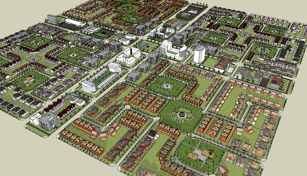 |
| A Fused Grid district with four quadrants and a mixed use zone |
The quality and efficiency of the Fused-grid has been tested in a number of studies variously involving Fanis, The Canadian Mortgage and Housing Corporation, graduate students of Canadian Universities, and Lawrence Frank (Canadian Bombardier Chair of Sustainable Transportation). These studies compare the Fused-grid to alternative street layouts (usually the traditional gridiron and conventional subdivision) to determine if the Fused-grid performs better in terms of vehicular traffic performance and pollution, travel behaviour, safety, and water management. All but one study use simulations and control areas such as Barrhaven (ON) and Stratford (ON) (a technique often used in geography and planning research) to determine how changes in urban form can influence relevant outcomes. However, one study conducted in the Puget Sound Region of the U.S. did use epidemiological methods to assess the cross-sectional (measured at one time point) association between urban form and travel behaviour. Additionally, a developer in Calgary, Alberta has implemented the Fused-grid layout in one of their developments - offering further insight into its applicability.
So what does this collective body of evidence show?
For a start, the Fused-grid reduces traffic delay more consistently than the gridiron and subdivision layouts and allows for better flow (and possibly less pollution) as the number of residential houses and places of employment increase in an area (1). In fact it has been estimated that pollution exposure would be lower in Fused-grid areas compared to gridiron, subdivisions and new urbanism developments (2).
 |
Figure 1. Comparison of pollution index and number of pedestrian encounters between different neighbourhood street layouts, provided by F. Grammenos and adapted from Jin, 2010 |
During peak travel times (rush hour), the Fused-grid was shown to restrict total vehicle kms traveled to just 5% on local roads, whereas this was 11% and 16% for the traditional grid and conventional subdivision, respectively (1). Obviously reducing traffic on local roads (where more people generally live) is a good thing. Safety can also be increased through the use of 3-way intersections over 4-way intersections. The Fused-grid tends to use 3-way intersections in a ratio of around 5:1 and overall has fewer intersections than the gridiron or even the conventional subdivision layout (3).
Vehicular kilometers traveled per trip in the Fused-grid is not shorter than in the gridiron (this is expected) indicating that the Fused-grid is less connected <for vehicles> (1), but remember that it makes up for this through the use of central open spaces for pedestrians and cyclists. In fact, making driving inconvenient and active commuting more convenient and pleasant is the central premise of this layout. In the only epidemiological study of the Fused-grid, areas with a street pattern similar to the Fused-grid (high pedestrian connectivity and low vehicular connectivity) were found to have the highest percentage of people deciding to walk (18%) compared to areas with low pedestrian connectivity/low vehicular connectivity (10%), low pedestrian connectivity/high vehicular connectivity (10%), and high pedestrian connectivity/high vehicular connectivity (14%)(4). Another study further supported these findings (see Figure 2 below)(2). Additionally, the Fused-grid has been shown to slightly cut down on the average distance required to get to transit stops compared to subdivision layouts (3).
Vehicular kilometers traveled per trip in the Fused-grid is not shorter than in the gridiron (this is expected) indicating that the Fused-grid is less connected <for vehicles> (1), but remember that it makes up for this through the use of central open spaces for pedestrians and cyclists. In fact, making driving inconvenient and active commuting more convenient and pleasant is the central premise of this layout. In the only epidemiological study of the Fused-grid, areas with a street pattern similar to the Fused-grid (high pedestrian connectivity and low vehicular connectivity) were found to have the highest percentage of people deciding to walk (18%) compared to areas with low pedestrian connectivity/low vehicular connectivity (10%), low pedestrian connectivity/high vehicular connectivity (10%), and high pedestrian connectivity/high vehicular connectivity (14%)(4). Another study further supported these findings (see Figure 2 below)(2). Additionally, the Fused-grid has been shown to slightly cut down on the average distance required to get to transit stops compared to subdivision layouts (3).
 |
| Figure 2. Comparison of percentage of people walking, driving, and using public transit between different neighbourhood street layouts, provided by F. Grammenos and adapted from Jin, 2010 |
The Fused-grid layout appears to be highly flexible, which can increase the diversity of the area. For instance, the new Fused-grid neighbourhood in Calgary, Alberta, provides various housing density options including townhouses, apartments, and houses (5). The proposed density (10.5- 12.1 units per acre) was twice that of densities typically found in conventional subdivision layouts. Other studies also show that the Fused-grid has more developable land (60%) than the traditional gridiron (53%)(1), and can connect more easily to future development areas than the conventional subdivision (3), indicating a great deal of flexibility for future growth.
Given the results thus far, the Fused-grid layout looks promising. However, some gaps remain. These mostly have to do with more intricate planning details that would probably be up to the developer to implement, as well as limited or facilitated by town/city by-laws. Some of these gaps could, on the other hand, be addressed in the layout itself. Recommendations to address these gaps are highlighted below:
| Table 1. Recommendations to improve the population health impact of the Fused-Grid layout | |
| 1. | General guidelines for planting of trees along streets, open areas and residential lots, as well as plans for landscaping of open spaces and common areas should be included in the layout. These plans should include spacing and orientation of trees with respect to buildings to provide efficient energy-reduction and protection from noise |
| 2. | At a minimum, plans for proper lighting of pedestrian connectors as well as way-finding signage should be included. Pedestrian-scale lighting should be designed to adequately light sidewalks (in addition to lighting provided to increase motorists’ safety). Points where pedestrians must cross vehicular streets should be well marked and easily visible to both motorist and pedestrian. Way-finding signage should point to crossings with the least pedestrian-motor vehicle conflict. |
| 3. | More common meeting spaces in the public realm need to be created to facilitate social interaction and physical activity. The routes to these spaces as well as the spaces themselves should make residents feel comfortable. The layout should also include the spatial layout of benches along streets and pedestrian pathways that face visually interesting backdrops (such as ponds, gardens, main streets, etc). The placement of these meeting and resting places should ensure that shade and wind protection are provided |
| 4. | Guidelines for designing bike lanes along lower traffic volume streets and/or mixed-use pathways, separate from the road system, should be included. At present, getting to a destination efficiently depends on where one starts within the neighbourhood quadrant. Providing extra pathways can improve route directness, thereby decreasing travel time. At least one sidewalk per street should also be provided. |
| 5. | The plan layout should provide extra areas of mixed land-use within neighbourhood districts (within the four quadrants) and promote mixed building use to commercial developers. |
| 6. | Guidelines should be provided on how to efficiently maximize diversity within the development (or neighbourhood to be retrofitted) in terms of building types and density. Providing rental units in single family homes should be encouraged. The Calgary developer has done this by introducing optional units with an accessory apartment. |
| 7. | The layout should strive to minimize impermeable (non-absorptive) surfaces, consider increasing lot size, and provide, not only a centralized green space for connectivity, but also small pockets of green space throughout the area - to improve rainwater management - a previous study did not show that the Fused-grid was any better than the traditional gridiron layout in this regard (6). The Calgary developer constructed rain gardens in each of the open spaces to improve rainwater management (5). |
All in all, the Fused-grid layout is a progressive concept that appears to capitalize on the benefits of both the traditional gridiron and conventional subdivision neighbourhood layouts. Further research is needed - as I discussed before - to determine if changing a community to fit the Fused-grid layout (or moving people into a Fused-grid neighbourhood) results in changes to behaviours and perceptions, traffic-related injuries and levels of obesity among residents. This is hard to do, but at the very least I think that future research on the Fused-grid would benefit immensely from incorporating some form of epidemiological method in addition to methods used in the geography and planning literature.
1. Grammenos F. (2008). Taming the flow - Better traffic and safer neighbourhoods Canada Mortgage and Housing Corporation Research Highlights, Report No.: 08-012.
2. Jin X (2010). Modelling the influence of neighbourhood design on daily trip patterns in urban neighbourhoods Doctoral Thesis Dissertation, Memorial University, Newfoundland
3. Grammenos F., & Gregory K. (2004). Applying Fused-Grid planning in Stratford, Ontario Canada Mortgage and Housing Corporation Research Highlights, Report No.: 04-038
4. Grammenos F., Frank L., & Hawkins C. (2008). Giving pedestrians an edge - Using street layout to influence transportation choice Canada Mortgage and Housing Corporation Research Highlights, Report No.: 08-013
5. Grammenos F. (2008). Breaking ground: A fused grid neighbourhood in Calgary Canada Mortgage and Housing Corporation Research Highlights, Report No.: 08-020
6. Grammenos F., & Pollard D. (2007). A plan for rainy days: Water runoff and site planning Canada Mortgage and Housing Corporation Research Highlights, Report No.: 07-013
No comments:
Post a Comment