Today's post is one part of a two-part series on how we can build better places to live. Here I will briefly describe different neighbourhood designs and their issues in terms of health and environmental sustainability. The second post will further analyze the 'fused-grid' design, a design that may allow for both health and sustainability to exist in harmony.
Now, to set the stage. Back in the olden days, neighbourhoods, towns, and cities were built to accommodate pedestrians and horse-drawn vehicles. This gave rise to the classic grid-iron street pattern - making it easy for someone on foot to get from point A to B. Because people could not get very far very fast, they had to live close to one another, to where they worked, and to markets where they could buy the necessities of living. The centres of very old European cities are great examples of this type of street design.
 |
| Barcelona, Spain: classic pedestrian-friendly streets |
 |
| Route directness: comparison between loop/lollipop and grid-iron street designs |
Suburban living is also not sustainable. Few people can argue with that. The amount of land is not infinite, nor for that matter, is oil. We also need somewhere to grow our food. Greenhouse gas emissions from cars are poisoning our air, and new residential developments and road construction threaten ecosystem health, as well established communities, which are often disadvantaged, and therefore lack the power and resources to protect what is theirs (7,8).
The pitfalls of sprawl have in large part led to the revitalization of the grid-iron street pattern of old, often referred to as 'neo-traditional,' as well as the rise in popularity of 'smart growth' and 'new urbanism': similar design mantras that focus on fostering a sense of community, mixing land-uses such as housing, commercial, and retail, are transit and pedestrian oriented, value the utility of green spaces, and often rely on the grid-iron street design.
Herein lies the problem: balancing what people want/can afford with sustainability and health.
Using the neo-traditional grid-iron neighbourhood pattern often means high-density housing. Many people still want single-family homes with a backyard, not a condo. For the average person or family, living 'downtown' in a condo is often not possible anyway due to enormous real estate costs.
The grid-iron pattern also requires a lot of paved surface area. This is bad for the environment in two main ways:
[a]As the percentage of street surfaces increases, the city becomes a ‘heat island’ with temperatures differentials that can be 5-10°C between the city and surrounding hinterlands (9). Increased temperatures in and around cities leads to enhanced ozone formation and increase the number of officially recognized smog days. The adverse influence of ozone is further enhanced via suburban sprawl which can project ozone to surrounding agriculture lands, decreasing crop yields by 5-10% (9);
[b] Streets are responsible for about 75% of total water runoff after a rainfall and are key sources of waterborne particles and pollutants from the built environment, which necessitate water treatment (10).
Finally, if a move to more high-density living is not accompanied by reductions in automobile use and investment in city infrastructure such as construction and maintenance of sidewalks and parks, mixed land-use development, public transportation, and sewage and water treatment systems, health and sustainability problems would stay the same or even worsen.
How can we then fix suburban sprawl if we can't use street designs that worked in the days of horse and buggy?
Certainly ALL urban planning should follow smart growth/new urbanism principles. However, in Canada, there is a large gap between what is proposed and what actually gets done (11) ; never mind the fact that not all cities and municipalities even 'propose' to follow these healthy and sustainable building principles.
The answer may lie with a neighbourhood design that fuses the grid-iron and conventional sub-division designs. It is aptly named the Fused-grid Design (FG); a design that consists of a discontinuous grid of local streets (quadrants, quartiers, or quarters) surrounded by a continuous grid of collectors and arterial roads that provide connectivity for regional and district travel. Keeping local streets discontinuous, as in conventional suburban design, increases safety and tranquility for residents. The almost exclusive use of 3-way intersections also increases safety.
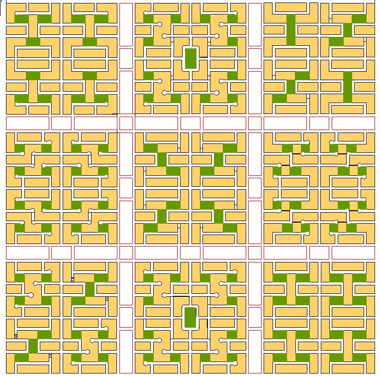 |
| A Fused-Grid District with 36 neighbourhoods |
The design is flexible in that there are many different configurations of street patterns with open space and housing densities (as can be seen in the picture). For example, one quadrant could contain exclusively high density or low density housing. Alternatively, high density housing could be placed on the perimeter of the quadrant, with single family housing located in the interior. Mixed land-use zones separate quadrants, and provide areas to develop schools, parks or businesses (white area with red lines). If population growth places too much stress on existing infrastructure, these areas can also be used for road redesign and/or expansion within the existing road allowance (13).
New developments can use the FG but old grid-iron and conventional subdivision designs can also be retrofitted to the FG design. This design idea does not seem to be new - older European cities such as Munich appear to already be using these design principles.
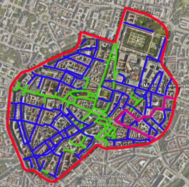 |
| Three distinct FG quadrants in Munich, Germany |
References
(1) Duany A, Plater-Zyberk E. The traditional neighbourhood and urban sprawl. New Urbanism and beyond: Designing cities for the future.New York: Rizzoli International Publishers; 2008. p. 64.
(2) Nozzi D. Speed, size, and the destruction of cities. New Urbanism and beyond: Designing cities for the future.New York: Rizzoli International Publishers; 2008. p. 89.
(3) Malizia EE. City and regional planning: a primer for public health officials. Am J Health Promot 2005;19(5):Suppl-13.
(4) Shields M, Tjepkema M. Regional differences in obesity. Health Rep 2006;17(3):61-7.
(6) Dunton GF, Kaplan J, Jerrett M, Reynolds KD. Physical environmental correlates of childhood obesity: a systematic review. Obes Rev 2009 Jul;10(4):393-402.
(7) Lopez R, Hynes HP. Obesity, physical activity, and the urban environment: public health research needs. Environmental Health: A Global Access Science Source 2006;5(1):25-32
(8) Savitch HV. How suburban sprawl shapes human well-being. J Urban Health 2003;80(4):590-607.
(9) Pickett STA, Cadenasso ML, Grove JM, Nilon CH, Pouyat RV, Zipperer WC, et al. Urban ecological systems: Linking terrestrial ecological, physical, and socioeconomic components of metropolitan areas. Annual Review of Ecology and Systematics 2001;32:127-57.
(9) Pickett STA, Cadenasso ML, Grove JM, Nilon CH, Pouyat RV, Zipperer WC, et al. Urban ecological systems: Linking terrestrial ecological, physical, and socioeconomic components of metropolitan areas. Annual Review of Ecology and Systematics 2001;32:127-57.
(10) Engel-Yan J, Kennedy C, Saiz S, Pressnail K. Toward sustainable neighbourhoods: the need to consider infrastructure interactions. Can J Civil Eng 2005;32:45-57.
(11) Canada Mortgage and Housing Corporation. Smart Growth in Canada: A Report Card. 2005
https://www03.cmhc-schl.gc.ca/catalog/productDetail.cfm?lang=en&cat=44&itm=71&fr=1290436546890
(12) Grammenos F. The Fused Grid: A contemporary urban pattern. http://www.fusedgrid.ca/fusedgrid.php
(13) Canada Mortgage and Housing Corporation. The Fused Grid: A neighbourhood and district layout model. http://www.cmhc-schl.gc.ca/en/inpr/su/sucopl/fugr/index.cfm
I think the healthy design of the streets is a good idea, but no one will want to live in a high density only area, nor will they want to live near a massive shopping area that are all too common in our current cityscape.
ReplyDeleteThis is certainly a good solution, but can it be done in a way that people don't need to use cars. Can we get there from our current mess? People need to use their cars to get their shopping done at centers that are so massive that they need many people sustain them. Isn't the reason we have these massive shopping areas because it is, or at least appears cheaper for the consumer? Clearly there are hidden costs of the last mile transportation.. which is where the Super Stores came from.